Well into the twentieth century, pockets of African-American residents were scattered across the western side of Wilson. This map will help you visualize the locations of these communities should you see their names.

Well into the twentieth century, pockets of African-American residents were scattered across the western side of Wilson. This map will help you visualize the locations of these communities should you see their names.

As noted in the earlier “Lost Neighborhoods” posts, downtown Wilson was once shot through with narrow alleys packed with the tiny double-shotgun dwellings of African-American tobacco workers. Was Woodard Bottom such a neighborhood?
As noted in the earlier “Lost Neighborhoods” posts, downtown Wilson was once shot through with narrow alleys packed with the tiny double-shotgun dwellings of African-American tobacco workers. The whole of Sunshine Alley ran one and a half blocks between Tarboro and Mercer Streets, in the shadow of Liggett & Meyers’ tobacco warehouse and within a block of Planter’s Warehouse, Banner, Monk-Adams, Farmers, and Watson Warehouses. The neighborhood survived a 1924 fire, but by the end of 1928 it was gone — obliterated to make way for the massive Smith’s Warehouses A and B. (You can read a whole page about Smith’s in the nomination report for the Wilson Central Business-Tobacco Warehouse Historic District, but you’ll find no mention of Sunshine Alley.)
Here’s Smith’s in the 1940 aerial of Wilson, occupying the entire block bounded by East Jones, South Goldsboro, Hines, and Mercer Streets.

Today there’s nothing in this block but a Family Dollar store. Stand at the mouth of its driveway at Goldsboro Street. Look west:

Then east:
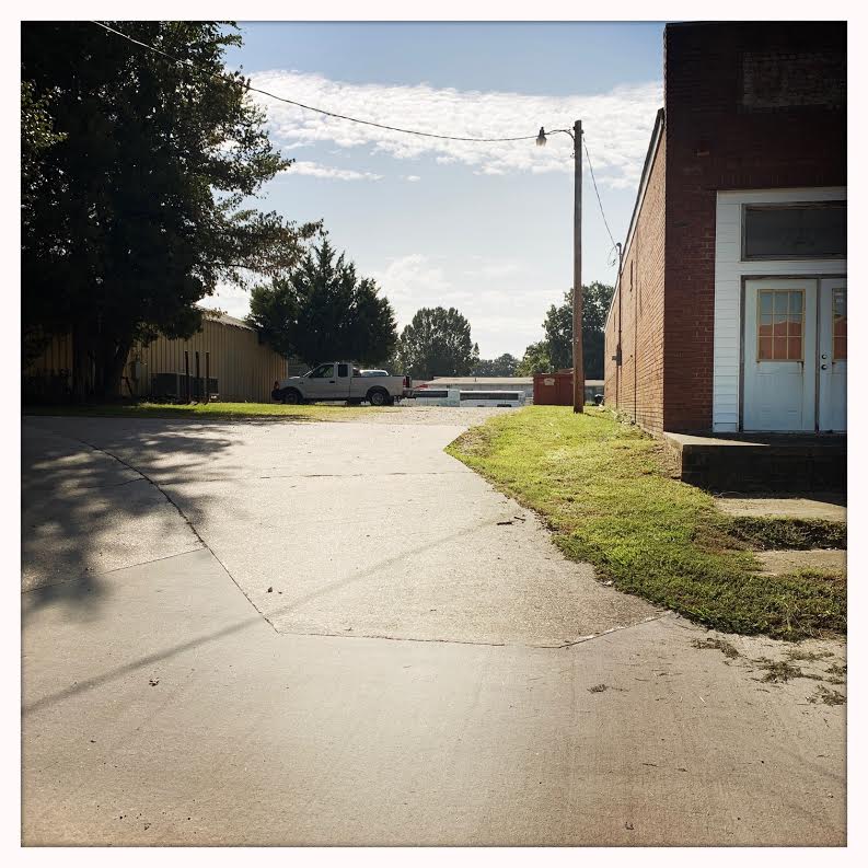
This was Sunshine Alley.
Photos by Lisa Y. Henderson, September 2020.
I received a thoughtful letter from a former Grabneck and Daniel Hill resident expressing disappointment in my use of the colloquial term “‘hoods” to refer to African-American neighborhoods in Wilson and requesting that I adopt a different word. I intended no disrespect to these communities (of which I am a product), but my intent is less important than the impact of my language choice. I have changed all such references to the neutral “neighborhoods.” Thank you, J.A.J.B., for reaching out and for your kind words re Black Wide-Awake.
“There were two ice companies near the railroad tracks and one area was called ‘Happy Hills’ where a few blacks lived. ‘Green Hill’ near the other ice company was a white neighborhood.” — Roy Taylor, My City, My Home (1991).
The Happy Hill neighborhood, wedged between the railroad and Lodge Street south of Hines, developed as early as the 1920s. In the 1950s, the city of Wilson began “slum clearance” in the area. Per the article accompanying the photo below, to avoid condemnation, property owners were forced to add two rooms and two baths to 19 four-room Happy Hill dwellings, each housing two families living without running water or toilets. Eventually, with federal funds, the city condemned and demolished the houses anyway and erected W.T. Adams Elementary School (now Saint John Community Development Corporation) and Whitfield Homes housing project (much of which is now shuttered) in the area formerly known as Happy Hill.

Wilson Daily Times, 7 January 1955.
Happy Hill was designated as a street address in the 1940 census of Wilson:

The 1947 Hill’s Wilson, N.C., city directory contained this description of the neighborhood:

In the earliest known map of Wilson, drawn in 1872, the Wilmington and Weldon Railroad marked the town’s eastern border. Beyond lay the plank road, a toll house, and a smattering of buildings, but the territory was essentially farmland. By 1882, town limits had pushed east to Pender Street, and a tiny commercial district had grown up at Nash and Pettigrew Streets, convenient to railroad workers, customers and passengers. Although African-Americans owned substantial plots of land along Pender, Stantonsburg and Manchester Streets and the Plank Road [East Nash], the area also contained large farms owned by well-to-do whites. However, with the arrival in the 1890s of tobacco stemmeries and a cotton gin near Railroad Street, working-class neighborhoods such as Little Richmond sprang up. Black businesses and churches solidified their claim to Pender Street end of Nash, and Samuel H. Vick and others began to lay the grid of East Wilson’s streets.

Sanborn fire insurance map, 1885.
Newspapers offer glimpses of the early development of East Wilson. References to the area “below the railroad” — “across the tracks,” in more modern parlance — regularly appeared in the pages of Wilson’s several late nineteenth-century journals.
Burford & Hinnant operated a meat market below the railroad, most likely at Nash and Pettigrew. Their 1883 notice advertised their steaks to customers and solicited “fat cattle” from area growers.

Wilson Advance, 30 November 1883.
Perry Taylor’s grocery/saloon/pool hall stood at one corner of Nash and Pettigrew Streets. The combination was a popular one. This ad appeared in January 1884, but the reference to Christmas suggests that it had first run earlier. Taylor had bought out grocer James Batts and could “whet your whistle” 24 hours a day.

Wilson Advance, 18 January 1884.

Wilson Advance, 4 April 1884.
Stilley & Wooten advertised tobacco products, including “Black Nancy fine-cut tobacco and “Sweet Violet” cigars. In the context of retailers, “below the railroad” in this period seems to have meant the vicinity of Nash and Pettigrew Streets.

Wilson Advance, 5 December 1884.
The 1888 Sanborn fire insurance map of Wilson shows the addition of rail lines and businesses to support them. Note, just below the “small lumber yard” at right, an area marked “Negro tenements.” The brick commercial buildings fronting Nash between the railroad and Pettigrew Street were known as the Fulcher block after prominent merchant L.H. Fulcher.

By the 1890s, newspapers — the Advance leading the way — were making hay with the contents of Wilson’s police blotter and criminal court dockets. Crimes alleged to have been committed by African-Americans received conspicuous, and, if at all possible, outlandish coverage.

Wilson Advance, 21, April 1892.
In January 1893, a fire devastated the “colored Odd Fellows Hall” on Nash Street. White grocer Golden D. Walston, who rented storage on the hall’s first floor, was fortunate to have insurance to cover his loss. (The order rebuilt its lodge later that year, erecting a three-story building that towered over the block for nearly one hundred years.)

Wilson Advance, 5 January 1893.
E.G. Rose operated another liquor store-cum-grocery store below the railroad.

Wilson Advance, 11 May 1893.
Finch & Lamm was perhaps a general merchandise store.

Wilson Advance, 2 August 1894.
The last decade of the 1800s saw the break-up of the farms and large lots that made up much of the east side’s property holdings. When Zillah Edmundson died in 1896, her estate sold her six-room house on five acres at Vance and Pender Streets to a seller who immediately flipped it. Before long, the former Edmundson property had been subdivided for house lots, and East Wilson’s familiar grid began to take shape.

Wilson Advance, 8 August 1896.

Wilson Daily Times, 23 October 1896.
Here was a complicated adaptive reuse: Briggs & Flemming converted the former Baptist church building on West Green Street to use as a tobacco prize house. Silas Lucas bought the building, removed the steeple, and planned to move it below the railroad to the former location of the Tate house for further repurposing as a tenement house. The target tenants, presumably, were African-American. Wilson’s black workforce was booming with the influx of former farmhands seeking factory jobs. (Was this the tenement house on Vance Street that Samuel H. Vick came to own, the building that came to house the Independent School after 1918?)

Wilson Advance, 21 January 1897.
Across Wilson, buildings overwhelmingly were constructed of wood, and fires were an ever-present danger.

Wilson Daily Times, 23 April 1897.
This article covering the criminal docket verged into an opinion piece in 1897. By that time, “below the railroad” was understood to mean the town’s black residential area.

Wilson Advance, 11 November 1897.
In 1898, Benjamin M. Owens moved a wooden building on East Nash Street to make way for “two nice brick stores.”

Wilson Advance, 7 July 1898.
In 1899, Mack D. Felton advertised his fish market (outfitted with one of Wilson’s earliest telephones.)

Wilson Daily Times, 5 May 1899.
In 1899, with the financial assistance of local merchants, the town assigned police patrol at all hours below the railroad. Later that year, as winter approached, city council appointed a committee to find a space in the area for police to warm themselves during the night shift.

Wilson News, 2 March 1899.
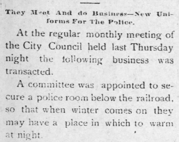
Wilson News, 12 October 1899.
After the turn of the century, references to “below the railroad” became less common. However, in 1911, Charles H. Darden & Son employed the term in an ad for their bicycle repair shop. With more businesses now lining the streets across the tracks, a specific address was a useful bit of information.

Wilson Daily Times, 17 March 1911.
Another shooting. The 1908 Hill’s Wilson, N.C., city directory lists Benjamin H. Moore as the owner of a grocery on Nash Street near the city limits. Henry Stewart appears in the directory as a laborer living at 127 East Nash. Orlando Farmer was a porter at Wilson Grocery Company, no home address listed.

Wilson Daily Times, 8 August 1911.
Another fish market. Gillikin’s is listed in neither the 1908 nor 1912 city directories.

Wilson Daily Times, 22 December 1911.
Late in 1918, the city announced that it was moving the town lot from Pine Street to Barnes Street.

Wilson Daily Times, 3 December 1918.

Is this collection of sheds the town lot? The 1922 Sanborn fire insurance map shows it across from Farmer’s Cotton Oil Company and adjacent to Wilson Chapel Missionary Baptist Church.
It’s hard to imagine that a twenty-five-dollar theft warranted bloodhounds from Raleigh, but ….

Wilson Daily Times, 25 February 1919.
![]()
Charlie Hines’ listing in the 1920 Hill’s Wilson, N.C., city directory. East Nash Street “extended” was the stretch beyond city limits, near Nestus Freeman’s home. In this period, the city’s southeastern edge crossed East Nash at Wainwright Avenue, at the approximate location of today’s Round House and Museum.
This article announcing a celebration marking the opening of the black-owned Commercial Bank noted that tickets could be purchased at Shade’s Drugstore, below the railroad at 530 East Nash.

Wilson Daily Times, 1 April 1921.
Early in 1925, Samuel H. Vick appeared before Wilson’s board of aldermen to request funds for “the colored hospital” and streetlights from the railroad to the intersection of Nash and Pender Streets. (A “whiteway” is a brightly lighted street, especially in a city’s business or theatre district.) Vick pointed out the bad optics of one well-lit side and the other dark to train passengers. The mayor raised the usefulness of good lighting to police officers.

Wilson Daily Times, 10 February 1925.
Though decreasingly cited, the term remained in currency at mid-century. In 1952, after considerable public controversy and contention, Wilson’s board of commissioners approved appointment of a housing authority to determine the extent of the city’s need for federally funded public housing. As this snippet of an article attests, black citizens crowded the hearings, testifying to the intense post-war housing shortage “below the railroad.”

Wilson Daily Times, 6 December 1952.
On 12 October 2018, the New York Times published a piece with the straightforward title “A Map of Every Building in America.” Its interactive map is endlessly fascinating at multiple levels. Below, the city of Wilson today:

Detail of the southeastern section of the city, with these historical African-American neighborhoods and places highlighted: (1) the heart of East Wilson; (2) the location of the Colored Graded School; (3) Rountree Place (nearly all of the houses in this triangle were cleared in the late 1990s to make way for Freeman Place, a multi-phase affordable housing development); (4) D.C. Suggs’ property (just above it, the site of the first colored cemetery; (5) Vicksburg Manor; (6) South Lodge Street; (7) Rountree cemetery; (8) Rest Haven cemetery; and (9) the Masonic cemetery:

Detail of the near-northwestern section of the city, with these historical African-American neighborhoods highlighted: (1) Grabneck; (2) New Grabneck; (3) Daniel Hill; (4) Finch’s Mill Road; (5) Lee and Pine Streets. (The waterway visible in its wide floodplain is Hominy Swamp.)

As illustrated in earlier “Lost Neighborhoods” posts, downtown Wilson was once shot through with narrow alleys packed with the tiny double-shotgun dwellings of African-American tobacco workers. In addition to Banks Alley and Oil Mill Alley and Parker’s Alley (also known as Vick’s Alley) and Young’s Alley, there were:
Sunshine Alley lay in the shadow of Liggett & Meyers’ tobacco warehouse and within a block of Smith’s, Planter’s Warehouse, Banner, Monk-Adams, Farmers and Watson Warehouses. As shown in the 1922 Sanborn fire insurance map of Wilson, the western end of the alley was a slot off Goldsboro Street in the block otherwise bounded by Hines, South Mercer and East Jones Streets.

The eastern end formed a dogleg dividing the block bounded by Goldsboro, Hines, Spring and Jones Streets.

Sunshine Alley is long gone, but its path is easily followed in the driveway of the Family Dollar store at Hines and Goldsboro, the driveway of Barrett’s Printing House (the white-roofed structure below standing within the former footprint of Smith & Leggett) and the cut-through that continues past Barrett’s to Douglas Street (formerly Spring).

Only a block long, Walnut Alley ran parallel to South Spring (Douglas) and South Lodge Streets between East Walnut and East Banks Streets. The 1922 Sanborn fire insurance map depicts a small “colored church” on Spring.

That church is now Saint Rose Church of Christ, and the alley is Walnut Lane.

Current maps courtesy of Google Maps.

Wilson Advance, 16 February 1899.
——
Wrote Bainbridge and Ohno in Wilson, North Carolina: Historic Buildings Survey (1980):
“Finch’s Mill Road was developed in the 1920’s on the former site of a shantytown.”
The “shantytown,” of course, was an African-American community. Until the 1920s, Finch’s Mill, like nearby Grabneck, was a black westside neighborhood.
“A natural extension of Residence Park, lying between that neighborhood and the main road to Raleigh (Rt. 264), Finch’s Mill Road, as it name suggests, once led to Finch’s Mill, outside of Wilson. A major change in the roadway in the 1920’s and then again in the 1970’s has changed this neighborhood. In the 1920’s Finch’s Mill Road became a less traveled way and it linked the older residential neighborhoods to the fashionable neighborhood which was to grow in the 1930;s along the Raleigh Road axis beyond Recreation Park. Finch’s Mill Road sill branches this gap between the old and the new neighborhoods. The character of the neighborhood is mainly residential, although the Recreation Park creates a large public open space. A few houses were built here in the 1920’s, but the bulk of the growth of the neighborhood took place after 1930, although few houses are being constructed in the 1970’s.”
Here is Finch’s Mill Road as depicted in the 1922 Sanborn fire insurance map, branching west off the northern end of Kenan Street and heading out toward Nash County. It is lined with tiny duplexes, likely no more than one or two rooms per side. (Finch’s Mill Road is now Sunset Road. South Bynum roughly follows the course of today’s Raleigh Road; the little spur is Cozart Road; and Sunset Drive is now Sunset Crescent.)

In the 1910 census of Wilson township, Wilson County, 29 households appear on Finch Mill Road, every single one of them African-American.

Excerpt from 1910 census of E.D. 114, Wilson township, Wilson County.

Wilson Daily Times, 22 October 1918.
In 1920, the census taker recorded 23 households on Finch’s Mill, mostly African-American, but with a sizable white minority. All were farmers, and none of the black heads of household owned their land. Soon, however, there would be no farmers of any kind at the end of the road nearest town.
In the mid 1920s, a large swath of the neighborhood, now known as Westover, was subdivided into “high-class residential” lots on Kenan and Bynum Streets, Sunset Road and Sunset Crescent, and offered for sale at auction:

Wilson Mirror, 16 December 1924.

Wilson Mirror, 17 December 1924.
By 1930, the old neighborhood was gone. Hill’s Wilson, N.C., city directory for that year lists only four occupied households on “Finch’s Road” and only one by an African-American family, the Reeds at #630. It’s not entirely clear what thoroughfare was considered Finch’s at that point, as the section of Finch’s Mill off Kenan Street had been rechristened Sunset Road and was home to Wilson’s white elite. The 1930 census lists cotton merchant Willie T. Lamm in a $25,000 house on “Westover.” Next door, in what may have been the last of the little duplexes shown on the 1922 Sanborn map, this household: Louisiana-born farmer Zion Read, 56, his North Carolina-born wife Lara, 25, and children Zoreana, 8, Hesicae, 12, William, 4, and Walter E., 0, in one half, and farm helper Jack Dixon, 25, wife Hattie, 24, their children John H., 3, and Susie M., 0, and a roomer Fes Scarboro, 45, in the other. Each family paid $6/month rent. Nearby, wholesale distributor John J. Lane was listed in a $15,000 house at 1015 Sunset Drive.

This Google Maps image shows today’s short stretch of Sunset Road, formerly Finch’s Mill Road, between Kenan Street and its dead-end at Recreation Park Community Center. The old road would have skirted the swimming pool and continued west across Hominy Swamp toward Finch’s Mill, five miles away near what is now the intersection of Raleigh Road/U.S. 264 and Interstate 95.
——

Wilson Daily Times, 15 November 1910.
Suggs Heights appears to comprise part or all the D.C. Suggs properties platted in the early 1920s.

“Ask any man who has property to rent what kind pays the most on the investment and he will tell you colored property.” [Likely because one could readily overcharge.] Wilson Daily Times, 11 December 1925.
Stantonsburg Heights may be the area platted as Vicksburg Manor.

“This high class colored development will build up in good homes and gardens.” Wilson Daily Times, 8 May 1945.
[A note about “Heights.” Wilson sits it in North Carolina’s Upper Coastal Plain at 108 feet above sea level. The eastern half of the county, including the city of Wilson, is notably flat, and low-lying areas flood notoriously. Neither of the areas advertised above are “heights” in any common understanding of the term, and it’s questionable whether the latter area could reasonably be described as high or dry.]