I had no idea what I was looking at at first. This aerial view of Wilson was shot circa 1949, but what was the perspective?
I started with the obvious landmarks — the courthouse, the Atlantic Coast Line Railroad, and the Cherry Hotel. The hotel’s location identified the street crossing the image diagonally as Lodge Street. Hines Street had not been cut through yet — it ended at Lodge — and Renfro Bridge was 25 years in the future. The image began to make sense.
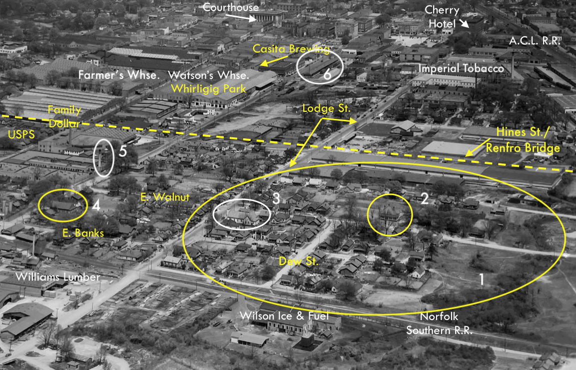
I’ve marked up the image with a few notes.
The footprint of the immense Watson’s Warehouse is now the site of Vollis Simpson Whirligig Park. The tobacco warehouses across Goldsboro Street from the park have been repurposed, but most of the warehouses visible in this image succumbed to fire in the 1980s and ’90s.

(1) The big oval (which is yellow, but should be white, as it indicates a lost or altered landscape feature) is roughly the neighborhood once known as Happy Hill. The neighborhood was razed in the 1950s to make way for the Whitfield Homes public housing project.

Whitfield Homes as shown on Google Maps. Most of these units have been demolished.
Wilson Housing Authority has largely replaced Whitfield Homes with 32 townhomes painted in cheery pastels. The pandemic delayed construction of the homes, but they opened in late summer 2022.

Eatmon Townhomes on East Walnut Street.
(2) The house at 515 East Walnut Street is one of the last remaining of the neighborhood’s original housing. Built when the block was a white residential area, the house is now owned by the General Assembly of the Church of the Lord Jesus Christ of the Apostolic Faith, whose popular Whole Truth Lunchroom stands next door. (The church bought the house and three contiguous lots from Asa and Annie Locus in 1950.)

(3) Mount Zion Holiness Church. This building has been demolished, and the church has not been active since at least the early 1970s.

Wilson Daily Times, 16 January 1935.
(4) Saint Rose Church of Christ Disciples of Christ is very much an active congregation, but in a newer edifice built along side this one.
(5) The chimney and water tower of the old British-American Tobacco Company facility on Goldsboro Street. Both remain standing, though the business is defunct.
(6) The old freight platform of the Norfolk Southern Railroad. The buildings still stand, but are not railroad property. [Who remembers what was across the street at 219 South Street, a two-story brick building was erected in 1928? The Twenty Grand Club, a nightspot torched by arsonists in 1984.] The former Norfolk Southern passenger station is at the corner of Barnes and Douglas Streets and is now home to a church and Islamic center.

This detail from a 1951 map of Wilson issued by the Chamber of Commerce helps us more clearly understand the street layout in the foreground of the Raines and Cox aerial view. Though the main railroads remain active, all the spur tracks shown were abandoned and either pulled up or paved over.
The black and white image is found among the Raines & Cox collection of photographs at the North Carolina State Archives and is catalogued as PhC_196_CW_1483_WarehouseDistrict. Other than the Google Maps image, all other photos are mine. The full map of Wilson may be found at East Carolina University Digital Collections.