Though I will always be of Wilson, I have lived in Atlanta for most of my adult life. It is very much “home” for me, too, and is a bottomless well of African-American culture and history that often informs the way I process research and works related to Black Wide-Awake and Lane Street Project.
I’ve begun visiting metro Atlanta’s historic African-American burial grounds. How have they weathered exploding population growth, shifting demographics, outmigration, land loss, and other pressures? The fifth in a series — Basket Creek Baptist Church Cemetery, Douglas County.
——
Listed on the National Register of Historic Places since 2009, Basket Creek Cemetery is singular in all of Georgia as the only documented burial ground with grave mounding, a practice with roots in West Africa. Per Wikipedia, the cemetery is classified as Southern Folk-style, with mounded graves, scraped ground, a hilltop location, east-to-west grave orientation, grave markers and decorations made with local materials (not commercially sold), certain types of vegetation, grave shelters, family plots, wife-to-the-left burials, and evidence of a devotion to God and/or family in the form of memorials.
Basket Creek Cemetery is astonishing in the very best sense of the word. Here are excerpts from the National Register nomination form:
Thomas J. Beadles Died Mar. 3, 1903 Aged 63 Yrs.
Thomas S. Endsley D. This Life March 17 1903
John T. Colclough Oct. 3, 1837 Oct. 7, 1914
“Simpson” Mr. William H. Endsley 5.10 1851 7.17 1923 (an Eldren Bailey headstone made for Simpson Funeral Home well after Endsley’s death)
I’ve been seeing (and puzzling over) Red Hill Cemetery for years. Death certificates and obituaries site it near Stantonsburg, but that post office serves both Wayne and Wilson County residents, and the cemetery’s precise location was not clear.
Detail of death certificate of Richard Artis of Stantonsburg, Wilson County, who died 29 November 1932.
Detail of death certificate of Phill Hines of Stantonsburg, Wilson County, who died 15 March 1946.
However, thanks to Portia Newman and her amazing grandfather, Donald L. Woodard Sr., I now know Red Hill is a few hundred feet beyond the Wilson County toward Eureka in Wayne County. It sits on a parcel of land owned by Bethel A.M.E. Zion Church of Stantonsburg.
I went on a chilly, dark, drizzly morning to have a look.
Though active as late as the 1970s, there is no obvious entry into Red Hill Cemetery.
I finally struggled in via a deer path, but could not advance very far through snarls of greenbrier. An estimated 250 graves lie here, but I did not see any headstones or other markers.
I first mused about the cemetery on the old Joshua Barnes plantation here. As shown in this detail from the plat, the burial ground was in Lot 11 of the farm’s subdivision, a triangle of land between what are now London Church Road and Corbett Avenue. Was this where black tenants and laborers on Barnes’ farm buried, well into the 20th century? Did it start as a cemetery for the many dozens of people Barnes enslaved?
Last week, I stumbled upon a 1964 plat map of the former Lot 11, then named Raeford Rountree farm, which outlines the cemetery in greater detail and records its size as .73 acres.
This deed description comes from a 1983 quitclaim deed from Landmark Development Company of Wilson to a trustee for Living Faith Ministries, Inc. It makes clear that this cemetery was recognized for what it was.
Here’s a current aerial view of the property from Wilson County’s GIS website. I’ve encircled the rough location of the cemetery, which lies a short distance south of Impact Church.
There’s no sign of the cemetery now. (At least not from the road.)
A reminder that Wednesday night I’ll be at Wilson County Public Library talking about historic African-American cemeteries outside Wilson — where we find them, who they served, and how their existence is challenged.
Some view my insistence on independent investigations into what happened to Vick Cemetery’s headstones; the location of graves in the public right-of-way bordering Vick Cemetery; and how power poles came to be installed in Vick Cemetery as retributive.
They are wrong.
There can be no justice for the dead (or living) harmed by the City of Wilson’s decades of action and inaction at Vick Cemetery. We will never know all the names of the 4224+ dead. We will never recover their grave markers. We will never whose graves — or how many — were cracked open or crushed in the widening of Lane Street or the placement of 90-foot power poles and their attendant guy wires.
What we can determine, however, is HOW THESE OUTRAGES WERE ALLOWED TO HAPPEN and, consequently, what systems, policies, and procedures can be put into place to prevent anything like them from happening again.
Last week, I received a set of photographs that reminded me that Vick Cemetery is not unique in Wilson County and that shortcuts and conveniences (or inconveniences) and indifference and neglect have left their shameful mark elsewhere.
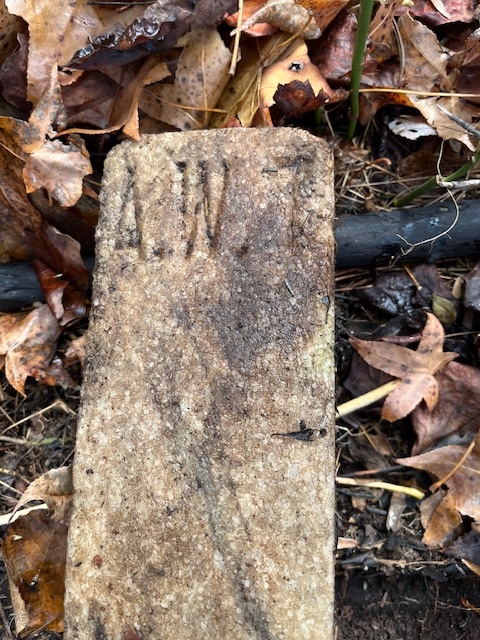
I’ve written of Buckhorn Reservoir and the headstones of Julia Boyette Bailey and Andrew W. Terrell before. In a nutshell, Wilson County Register of Deeds Office’s “Grave Removals” volume, which contains records of every registered disinterment and/or reinterment in the county for the past 50 or so years, contains no record of the removal of the graves of Julia Bailey, Andrew Terrell, or the 16-18 unknown others whose disinterment was publicized in 1998 ahead of the expansion of Buckhorn Reservoir.
As the headstones of Bailey and Terrell attest, the graves now lie at the edge or under the lake. There’s no record because the graves were never removed.
Al Letchworth took this photo of Terrell’s broken gravestone in 2019. It has since disappeared.
Here is Terrell’s foot marker, as photographed by Randy Marshburn last week.
And here are the grave markers of Julia Boyette Bailey, a woman who was born into slavery; grew to adulthood, married, and bore children under its yoke; and lived only four years beyond it. Hers is one of the, if not the, oldest known burials of an African-American person in Wilson County.
Buckhorn Reservoir is the primary water source for the City of Wilson. The City of Wilson is the owner of the reservoir and the dam that created it. Wilson Utilities is responsible for the reservoir’s management.
In 1998, during roughly the same period that the City of Wilson was throwing away headstones and drilling holes in Vick Cemetery to install power poles, it was on the other side of the county flooding black cemeteries to expand its reservoir.
What failures of process allowed this to happen? How do we prevent further failure? Is the City of Wilson prepared to be transparent about — and accountable for — its errors and misdeeds, or will it continue to whistle past the (figurative and literal) graveyard?
My profound gratitude to Randy Marshburn and Al Letchworth for these photographs and their deep concern for the graves of Julia Bailey and Andrew Terrell.
I was on my way to peek at the site of old Jones Hill School when I pulled up short. When I first posted about Jones Hill Cemetery, I had to fight my way in. Now — chainsaws, machetes, and weedwhackers later — look at it! Kudos to those who tackled this delicate task.
Not only are the cemetery’s headstones clear and clean, the depressions of unmarked graves are now clearly visible.
Per survey, there are 44 marked graves in Jones Hill (labeled Old Fields Cemetery at http://www.findagrave.com). Here a few:
Julious Locus, “He Followed Virtue As His Trusty Guide”
In the 1870 census of Oldfields township, Wilson County: Ganes Locust, 40; wife Zana, 35; and children Penny, 15, Hasty, 12, James, 9, Julius, 5, Sarah, 4, and Amanda, 1.
In the 1880 census of Oldfields township, Wilson County: farmer Gaines Lucas, about 55; wife Zaney, about 50; and children James, 18, Julius, 16, Sarah, 13, Amanda, 11, John, 9, and Fanny R., 5.
On 31 October 1886, Julius Locus, 22, married Zilley Ann Williamson, 20, at J.A. Jones’ in Wilson County. J.H. Jones and Penny Jones were witnesses.
On 7 October 1902, Julius Locus, 30, of Oldfields, son of Ganes and Zaney Locus, married Adelia Bryant, 34, of Oldfields daughter of Jim Bryant, in Oldfields township, Wilson County.
In the 1910 census of Oldfields township, Wilson County: Julius Lucas, 42; wife Adelia, 39; and children Ada, 14, Charley, 11, and Tincey, 1.
In the 1920 census of Oldfields township, Wilson County: Julius Locus, 55; wife Adelia, 51; children Ada S., 14 [sic], Tinsey, 11, and Mary Lizzie, 8; and servant Hattie Wyatt, 15.
Ben Coley, “At Rest”
Ben Coley was a Prince Hall Mason. [I know of only three lodges in Wilson County — Mount Hebron #42, Rocky Blue #56, and Pride of Wilson #484. Did Ben Coley belong to Rocky Blue?]
On 20 October 1883, Ben Coley, 19, of Nash County, son of James and Mary Coley, married Elizabeth Griffin, 18, of Nash County, daughter of Wesley and Nancy Griffin, in Griffins township, Nash County.
In the 1900 census of Oldfields township, Wilson County: Benjamin Coley, 38; wife Tempy, 35; and sons James, 16, and Eddie, 13.
On 6 January 1907, Ben Coley, 40, of Nash County, son of Jim Coley, married Tempie Arrington, 30, of Nash County, in Jackson township, Nash County.
In the 1910 census of Oldfields township, Wilson County: farmer Benjamin Coley, 47; wife Mamie [Tempie], 45; and granddaughter Mary, 3.
In the 1920 census of Oldfields township, Wilson County: Ben Coley, 60; wife Tempie, 60; granddaughter Maggie, 13; and servant George Kerney, 17.
Benjmon Colley died 10 February 1921 in Oldfields township, Wilson County. Per his death certificate, he was 56 years old; was born in Nash County, N.C., to James Colley and Marry Battle; was married to Tempey Coley; and worked in farming. J.A. Jones was informant.
William H. Bullock
In the 1910 census of Tarboro township, Edgecombe County, N.C.: farm laborer Owen Bullock, 39, widower; sons William, 14, and Moses, 12; and partner Rachel Bullock, age unknown.
In 1917, Henry Bullock registered for the World War I draft in Wilson County. Per his registration card, he was born 1 June 1896 in Wilson County; lived at R.F.D. #1; and worked as a quarry hand.
In the 1920 census of Oldfields township, Wilson County: farmer Joe Powell, 35; wife Alice, 19; son David R., 8 months; and brother-in-law William H. Bullock, 22, farm laborer.
On 3 March 1922, Wm. Henry Bullock, 25, of Nash County, married Estelle Coleman, 22, of Oldfields township, Wilson County, in Wilson County. Burley Graham and A.D. Dawson were witnesses.
In the 1930 census of Oldfields township, Wilson County: farmer William H. Bullock, 38; wife Estella, 32; and children Mary, 7, William, 6, Essie, 4, Bettie, 3, and Mattie, 1.
In the 1940 census of Oldfields township, Wilson County: farmer Henry Bullock, 44; wife Estella, 46; and children Mary, 17, William, 16, Essie, 14, Bettie and Mattie, 13, Pearlie, 8, Leonord, 7, James, 6, Charles, 4, and Henry, 5 months.
In the 1950 census of Oldfields township, Wilson County: farmer William H. Bullock, 53; wife Estelle, 55; children Essie, 23, Pearly L., 20 Leonard, 19, James, 16, Charles C., 15, Henry Jr., 10, and Jeraldine, 8; and grandchildren Erlene, 7, Edward L., 4, and Mattie B., 1.
William Henry Bullock died 1 March 1956 in Sims, Wilson County. Per his death certificate, he was born 31 January 1897 in Edgecombe County to Owen Bullock and Henrietta [no maiden name]; was married to Estelle Bullock; worked as a farmer; and was buried in Jones Hill Cemetery.
On 26 January 1929, Sylvester Parker, 20, of Taylor township, son of Tom and Emma Parker, married Gladys Knight, 19, of Taylor township, daughter of Jim and Caroline Knight, in Wilson, Wilson County.
Josiah Jones
This is the grave of either Josiah Jones, son of Noel and Sarah Jones, or Josiah Jones, son of Jacob and Milly Jones, who were born less than ten years apart. Both were buried in Jones Hill Cemetery.
In the 1870 census of Oldfields township, Wilson County: farm laborer Noel Jones, 26, wife Sarah, 23, and children Josiah, 3, Charity, 1, and Edith, 4 months.
In the 1870 census of Old Fields township, Wilson County: steam sawmill worker Jacob Jones, 43, wife Milley, 43, and children John H., 17, Stephen, 15, Joanna, 13, Josiah, 11, Nancy, 7, and Milly A., 3, plus Jesse, 21, and Eliza Jones, 21.
In the 1880 census of Oldfields township, Wilson County: laborer Noel Jones, 34, wife Sarah, 32, and children Josiah, 13, Charity, 12, Edieth J., 10, and Noel J., 6.
In the 1880 census of Oldfields township, Wilson County: Milly Jones, about 52, and children Josiah, 17, Nancy, 15, Milly A., 14, and Mibary, about 35.
On 27 January 1886, Josiah Jones, 22, [son of Jacob and Milly Jones?] married Hasty Locus, 26, in Wilson County.
On 15 March 1891, Josiah Jones, 25, son of Noel and Sarah Jones, married Thaney Jane Powell, 19, daughter of Jabe and Mary Powell, in Oldfields township, Wilson County.
On 6 January 1909, Josiah Jones, 40, son of Noah and Sarah Jones, married Lillie Barnes, 30, daughter of Richard and Phoeby Rountree, in Taylor township, Wilson County.
In the 1910 census of Oldfields township, Wilson County: Josiah Jones, 49; wife Fannie, 35; mother Millie, 85, widow; sister Sallie A., 37, widow; and nieces Lillie, 11, and Dinah Jones, 2.
Josiah Jones died 6 April 1939 in Cross Roads township, Wilson County. Per his death certificate, he was born June 1866 in Nash County, N.C., to Noah [Noel] Jones and Sarah Brown, both of Wilson County; was the widower of Lillie Roundtree Jones; was a farmer; and was buried in Jones Hill Cemetery. [Note the discrepancy between this information and the birth and death dates on the headstone — 22 July 1862 and 20 February 1925.]
Elijah Powell, “His toils are past, his work is done, he fought the fight — the victory won.”
In the 1910 census of Black Creek township, Wilson County: farmer Elijah Powell, 39, wife Sarah, 31, and children Roxie, 12, Daisy, 10, Emma L., 8, Bettie, 6, and Elijah, 3.
In the 1920 census of Black Creek township, Wilson County: on the Road to Horns Bridge, Elijah Powell, 51, wife Sarah, 45, and children Daisy, 19, Emma, 16, Bettie, 14, and Elijah Jr., 13.
Elijah Powell died 16 September 1928 in Wilson township, Wilson County. Per his death certificate, he was born 15 June 1907 in Wilson County to Elijah Powell and Sarah Tabron; farmed for Jimmie High; and was single.
John M. Lucas, K. of K.
John M. Locus (also Lucas) was a Prince Hall Mason, and “K. of K.” presumably indicated that he had achieved the rank of Knight of Kadosh, or 30th degree. [Did John Locus belong to Rocky Blue?]
In the 1880 census of Oldfields township, Wilson County: farmer Gaines Lucas, about 55; wife Zaney, about 50; and children James, 18, Julius, 16, Sarah, 13, Amanda, 11, John, 9, and Fanny R., 5.
In the 1900 census of Oldfields township, Wilson County: farmer John Locus, 27, and sister Fannie, 24.
On 6 February 1902, John Locus, 28, of Oldfields township, married Annie Batts, 22, of Oldfields township, in Oldfields township. Julius Locus and W.H. Jones were witnesses.
In the 1910 census of Oldfields township, Wilson County: farmer John Locus, 37; wife Annie, 31; and children Flonnie, 9, Floid, 8, and Levy, 3.
In the 1920 census of Oldfields township, Wilson County: on Old Wilson and Raleigh Road, John Locus, 43; wife Annie, 39; and children Floid, 17, Levi, 14, and Wiley F., 4.
Raymond Sessoms, “At Rest”
Raymond Sessoms died 31 May 1922 in Oldfields township, Wilson County. Per his death certificate, he was one year, three months, and 21 days old; was born in Wilson County to Haywood Sessoms and Maggie Batts; and was buried in a family cemetery.
Willie Coleman Jr.
Clarence B. Best engraved Willie Coleman Jr.’s headstone.
In the 1930 census of Oldfields township, Wilson County: farmer Willis E. Coleman, 28; wife Daisy, 22; and children James T., 2, Willis C., 1, and Montie, 1 month; brother-on-law Hubert L. Bynum, 13.
In the 1940 census of Oldfields township, Wilson County: farmer Willie Coleman, 39; wife Daisey, 32; and children John T., 14, Willie Jr., 10, Monnie M., 9, Bennie, 8, L.V., 6, Christine, 4, and Lula M., 2.
In 1946, Willie Junior Coleman registered for the World War II draft in Wilson County. Per his registration card, he was born 25 October 1928 in Wilson County; lived on Route 2, Wilson; his contact was Will Coleman; and he worked at J.D. Lamm farm.
In the 1950 census of Oldfields township, Wilson County: farmer Willie J. Coleman, 21; wife Naomah, 19; son Ronnie, 1; and siblings Bennie, 18, Christine, 14, Lula M., 12, Daisy L., 10, and Elisiah, 7.
John Jones’ father William Anderson Jones was the son of Nathan and Joanna Jones and grandson of Joseph and Zilla Locus Jones, and thus a member of the large extended Jones family with roots as free people of color in Nash County. Many are buried in the Jones Hill cemetery, which seems the most likely location for this baby’s grave. (Another of William and Amanda Rowe Jones’ children — William Thomas Jones — was buried in New Vester church cemetery in 1915, as was Amanda Jones after her death in Wake County in 1927.)
Our discovery of the remains of Barnes Primitive Baptist Church began with a search for a slave cemetery and a school believed to be in the same vicinity. I’m fairly certain Barnes School actually was once near by, but L. Paul Sherrod Jr. said he had heard conflicting information about the cemetery, and we saw nothing that suggested a graveyard. This burial ground would have been associated with the plantation of Dr. Edwin Barnes, whose family cemetery I featured in a post Friday.
Today, a chance find that confirmed we’re on the right track:
Wilson Daily Times, 23 April 1955.
David Ruffin‘s funeral was conducted at Barnes Primitive Baptist, and he was buried “in the Barnes cemetery near the church.” So there is, or was, a Barnes cemetery near Barnes Church. But where?
Here is Barnes Church in a 1940 aerial photograph. The light gray area below and southeast of the church, showing few trees, is worth exploring in a search for the cemetery.
——
In the 1900 census of Stantonsburg township, Wilson County: farmer Isaac Ruffin, 52; wife Chania, 55; and sons Isaac, 22, Dave, 17, Grey, 7, and William, 5.
On 31 December 1903, David Ruffin, 21, married Celie Barnes, 19, in Stantonsburg township, Wilson County.
In the 1910 census of Stantonsburg township, Wilson County: farm laborer David Ruffin, 24; wife Celia, 18; and children Clara, 7, and Daisy, 2.
In 1918, Dave Ruffin registered for the World War I draft in Wilson County. Per his registration card, he was born 6 January 1870; his nearest relative was Celia Ruffin; and he farmed for E.B. Graves.
In the 1920 census of Stantonsburg township, Wilson County: tenant farmer David Ruffin, 41; wife Cellie, 33; and children Daisy, 22, Dessie, 10, David Jr., 6, and Lula, 4.
Larsey Ruffin died 6 August 1926 in Wilson township, Wilson County. Per her death certificate, she was 18 years old; was born in Wilson County to David Ruffin and Celie Barnes; and worked as a tenant farmer.
In the 1930 census of Stantonsburg township, Wilson County: farmer Dave Ruffin, 50; wife Celia, 45; daughters Clara, 28, Daisy, 19, and Lola M., 16; son-in-law John Hales, 39; grandchildren John, 10, Dave, 7, and Maizie Hales, 5; and son Dave, 19.
In the 1940 census of Stantonsburg township, Wilson County: farmer Dave Ruffin, 50; wife Celia, 45; and [grandchildren] children David, 17, and Mazie, 15.
In the 1950 census of Stantonsburg township, Wilson County: Dave Ruffin, 78; wife Celia, 67; sons [sic] Walter Lee, 16, and George, 12; and sister Anna Artis, 77.
David Ruffin died 20 April 1955 at Route 3, Wilson. Per his death certificate, he was born 2 August 1893 in Wilson County to Isaah Ruffin and an unknown mother; was married; was engaged in farming; and was buried in Barnes Cemetery. Carrie Hayes, 202 Pettigrew Street, was informant.
Ten days later: Celia Ruffin died 30 April 1955 at 202 Pettigrew Street, Wilson. Per her death certificate, she was 61 years old; was born in Wilson County to Calvin Barnes and an unknown mother; was a widow; was engaged in farming; and was buried in Barnes Cemetery. Carrie Hayes, 202 Pettigrew Street, was informant.
We’ve spoken here and here and here of the plantation of Dr. Edwin Barnes, whose house sat near the intersection of modern Old Stantonsburg Road and Fairfield Dairy Road near those of his brother William Barnes and relative Wiley Simms. (Gen. Joshua Barnes was another brother.)
Edwin Barnes’ house was destroyed by fire in 2005. The sole trace of his tenure on the land is a small family cemetery tucked a few hundred feet from the home site under an enormous, lush boxwood. Here are buried Edwin Barnes, who died in 1885 at age 69; his wife Elizabeth Simms Barnes (1824-1875); and about a dozen assorted relatives.
But where are buried the dozens and dozens of men and women who worked Elias Barnes’ fields? We know the locations of just one or two slave cemeteries in Wilson County. Unmarked or impermanently marked, these sites are forgotten and largely untraceable — plowed under or overgrown in the decades since the last burial.
Wherever the dead may rest, we honor and pledge to preserve their memory.
The cemetery rattles with dried stalks of dog fennel.
Edwin Barnes’ marble stele. The cemetery on this early spring day was weedy and unkempt, but shows signs of at least fitful cleaning.