plat map

Property of Alphonzo Coleman.

In 1952, L.M. Phelps mapped the subdivided property of Alphonzo Coleman located near Wilson’s municipal airport.

cbvbcxghf

——

In the 1870 census of Wilson township, Wilson County: farm laborer Squier Coleman, 47, wife Nancy, 36, and children Gray, 18, Mary, 16, Afonzo, 9, Margret, 4, and Thomas, 2, plus Cassa Jordan, 70, Riley Jordan, 7, and Thomas Jordan, 25.

Alphonso Coleman, 21, married Annis Barnes, 18, on 18 September 1878 in Wilson County.

In the 1880 census of Wilson township, Wilson County: Alfonso Coleman, 21; wife Annise, 18; and sons Isaac, 1, and Henry D., 2 months.

In the 1900 census of Taylors township, Wilson County: farmer Alfonse Coleman, 42; wife Annis, 36; and children Jestus, 17, Minnie, 12, James, 11, Amous, 8, Richard, 3, Floyd, 4 months, Bessa, 9, and Ella, 5.

In the 1920 census of Taylors township, Wilson County: on County Line Road, farmer Alfonso Coleman, 63; wife Annie, 56; and children Minnie, 25, Amos, 22, Floyd, 20, Ella, 17, and John R., 16.

On 1 April 1929, Alfonza Coleman died in Taylors township, Wilson County. Per his death certificate, he was born in 1909 in Wilson County to Alfonzo Coleman and Annie Johnson; was married to Annis Coleman; was a farmer; and was buried in the Coleman cemetery.

On 15 June 1935, Amos Coleman died in Taylor township, Wilson County. Per his death certificate, he was born in 1896 in Wilson County to Alfonzo Coleman and Annie Barnes; was single; was a farmer; and was buried in the Coleman graveyard.

On 6 July 1936, John W. Coleman died in Wilson township, Wilson County. Per his death certificate, he was 73 years old; was born in Wilson County to Squire Coleman and Nancy Johnson; was married to Annis Coleman; was a farmer; and was buried in the farmer cemetery. Squire J. Coleman was informant.

On 27 August 1956, Square [Squire] Justuce Coleman died in Wilson township, Wilson County. Per his death certificate, he was born in 4 December 1881 in Wilson County to Alfonza Coleman and Annie Barnes; was divorced; was a farmer; and was buried in the Coleman cemetery.

On 11 October 1960, Minnie Coleman died in Wilson township, Wilson County. Per her death certificate, he was born in 1 January 1901 in Wilson County to Alfonza Coleman and Annie Jordan; was never married; and was buried in the Coleman cemetery.

Plat map 1, page 66, Register of Deeds Office, Wilson.

Property of the late Austin Neal.

Four years after his death in 1949, L.M. Phelps prepared a survey of barber Austin N. Neal‘s four lots and three houses on Wainwright Avenue.

srtdetyuy

The 1922 Sanborn fire insurance map of Wilson gives a wider view of the area and shows the larger house on the corner and one of the shotgun houses.

Freeman Street and Wainwright Avenue no longer intersect. This stretch of Wainwright is now Hines Street, and Freeman Street is blocked off.

The Neal house is still standing, now numbered 1218 Hines Street S.E. In 1988, when the nomination form for the National Register of Historic Places was submitted, all three houses (and a newer fourth) were accounted for: #1212, built circa 1930, 1 story, shotgun with turned-post porch; #1214, built circa 1930 [per the Sunburn map, earlier], 1 story, shotgun with turned-post porch and Masonite veneer; and #1218, built circa 1913, 1 story, Queen Anne cottage with double-pile, hip-roofed form, front-facing wing, and turned-post porch.”

Here’s a side view of the house, showing the blocked end of Freeman Street.

——

In the 1900 census of Freeman township, Franklin County: widower Austin Neal, 30, and children Bryant, 3, and Bertha, 1, plus brother Abram, 17, and sisters Tabitha, 19, and Bessie, 21.

In the 1912 Wilson city directory, Austin Neal was listed as a barber at 409 East Nash. His home address was “Wainwright av for Freeman.”

In the 1920 census of Wilson, Wilson County: at 105 Wainwright, widowed barber Austin Neal, 42, with children Bryant, 21, also a barber, Daisy, 16, Annie, 13, Samuel, 7, and Ruth, 5.

In the 1930 census, Wilson, Wilson County: at 1214 Wainright Avenue, barber Austin Neal, 61, wife Lizzie, 38, servant for a private family, and son Samuel, 18, a hotel bell hop.

Austin N. Neal died 14 February 1949 at Mercy Hospital of terminal uremia. He was born 11 November 1878 in Franklinton, North Carolina, to Abron Neal and Louise Brodie. He was buried in Rountree cemetery. Mrs. Lizzie H. Neal was informant.

Plat map 1, box 114, Register of Deeds Office, Wilson; photos courtesy of Google Maps.

Church 1/2 acre excepted.

Screen Shot 2020-03-06 at 7.24.33 PM.png

In 1917, Atlantic Coast Realty prepared a plat map subdividing the James W. Hayes Farm near Elm City into ten parcels. The farm’s location is readily identifiable as the tip of the triangle formed by present-day East Langley and Haynes Roads. At the tip of the tip, this notation: “Church 1/2 A, Excepted.”

Screen Shot 2020-03-06 at 7.25.22 PM.png

The original Little Union Primitive Baptist Church!

Plat book 1, page 40, Register of Deeds Office, Wilson; aerial view courtesy of Google Maps.

Negro cabins.

In 1914, Atlantic Coast Realty prepared a plat map showing the subdivision of Martin Applewhite’s Toisnot township farm into five parcels. The map shows the buildings on the property, in a “large house,” barns, and various dwellings, including two “Negro cabins.”

Screen Shot 2020-03-06 at 7.22.31 PM.png

Screen Shot 2020-03-06 at 7.23.02 PM.png

Plat book 1, page 18, Register of Deeds Office, Wilson. (Sidenote: some of these hand-drawn plat maps really are things of beauty.)

The Joshua Barnes graveyard.

Screen Shot 2020-03-06 at 7.39.09 PM.png

In 1918, Annie H. Branch, widow of Alpheus P. Branch Jr., sold the farm that had been owned by her husband’s grandfather, General Joshua Barnes. The ubiquitous Virginia-based Atlantic Coast Realty prepared a plat map of the property, dividing it into fifteen parcels. A road, split into a Y at its top end on the map (which is oriented south to north) was the spine of the Barnes/Branch property. The family’s house is shown just below the joinder of the Y’s arms. Within them, a saw mill and graveyard.

Was this the Joshua Barnes graveyard in which undertakers Wootten & Stevens buried several African-Americans, including Susan Parker and Thomas Hardy in 1897?

A modern aerial of the area readily reveals the Barnes house, the roads (London Church Road and Corbett Avenue), and the canal boundary, but no evidence of a cemetery (or a sawmill). Was it moved? Plowed under? What happened to it and when?

Plat book 1, page 65, Register of Deeds Office, Wilson; aerial map courtesy of Google Maps.

Harry Clark’s farm.

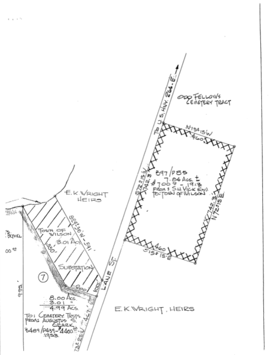
The city’s response to my request for documents about Vick cemetery yielded an unexpected bit of information. One of the plat maps revealed a property across Lane Street from Vick that the city’s Cemetery Trustees purchased from Augustus S. Clark of Cordele, Georgia, in 1953 for $4400. Partially visible next to it is a parcel marked “Bethel.”

The deed for the Augustus Clark parcel describes it as:

“The public road leading from Ward’s Boulevard pass [sic] Rest Haven Cemetery” is the western leg of what is now called Lane Street. “The road leading to Highway #264” is the eastern leg. Harry Clark was Augustus S. Clark’s father, and a 1921 plat map of his farm is annotated here:

In short, the southeastern half of Rest Haven cemetery was once the northeastern half of Harry Clark’s farm. In 1953, the Cemetery Commission purchased three tracts from the Clark family for the cemetery’s expansion.

On 23 January 1953, the same day A.S. Clark sold his share of his father’s estate, his niece Flora Clark Bethel and her husband Wilton Bethel sold Tract No. 6 to the Cemetery Trustees. (Flora C. Bethel had inherited the tract from her father, John H. Clark.)

On 5 June 1953, pursuant to a suit filed by the Cemetery Trustees against William H. Clark‘s heirs (widow Mary Clark, Thomas Clark and wife Sarah, A.S. Clark, Flora Clark Bethel and husband Wilton, A.S. Gaston, Theodore Gaston, Ralph Gaston and wife Dora, Cicero Gaston, George Gaston and unnamed wife, Russell Golding and unnamed wife, Flora Golding Parks and unnamed husband, and Harry Jenkins and wife Bertha), Tract No. 5 of the Clark farm was condemned. The heirs were awarded $3600, split according to their interests.

The road separating Tracts 1, 2, 3, and 4 from 5, 6, and 7 is now Lane Street, as is the road extending toward Martin Luther King Parkway from the dead-end of the first road. Tract No. 4 belonged to the heirs of Ella Clark Gaston Hinton, who died in 1947. The small black square in this tract shows the location of the Clark “home-house” (as the house recognized as the family seat is called in Wilson-speak.)

Here’s this area now:

The old path of Lane Street is clearly visible running alongside the softball field toward Stantonsburg Road. The electrical substation that the city lopped off A.S. Clark’s tract is the square of cleared land off Lane Street mid-frame. Vick cemetery is the field below Lane Street closest to the right edge of the frame. My best estimate is that the southwest half of Harry Clark’s farm stretched roughly from today’s Snowden Drive to the former path of Lane Street. The northeast half encompassed the portion of Rest Haven in which the sections widen over to Lane Street.

Plat Book 1, page 220; Deed Book 489, page 439, Register of Deeds Office, Wilson; Deed Book 489, page 437; Deed Book 499, page 353, Register of Deeds Office, Wilson. Aerial view courtesy of Bing Maps.

Lane Street Project: cemetery records request update, no. 5, the city’s response.

I have received the city’s response to my request for documents related to the removal and destruction of headstones from Vick cemetery, made under North Carolina’s Public Records Law.

My initial request to the Wilson Cemetery Commission was made 6 September 2019. (Thanks again to Heather Goff for her quick response.)

I followed up with letters to several city officials in October and November. The city clerk responded quickly to my first letter, providing copies of relevant city council minutes from 1990 to 1995. The city manager and city engineer did not respond at all, even to acknowledge receipt of my request.

On 30 December 2019, I sent a letter to the mayor of Wilson, the city manager, and all seven council members setting forth my concerns and my unanswered requests for information about Rountree, Odd Fellows and Vick cemeteries. At the behest of the city’s new mayor, Carlton Stevens, and council, city attorney James Cauley assumed responsibility for the search for responsive documents. I commend Mr. Cauley for his periodic updates on the status of the city’s response and for his candor concerning the paucity of records.

Here, in their entirety, are the documents I received.

(1) Purchase Order, dated 10 November 1994, for services by vendor PLT Construction, described in “Bid for improvements to S.H. Vick Cemetery.” The document’s right edge is cut off, but the amount the city paid was more than $139,000.

(2) A request for payment of balance due submitted by PLT Construction to the City of Wilson on 5 June 1995. Note the change item: “deduct for replacing headstones and portion of survey work.” PLT did not perform this work and thus credited the city $4500.


(3) A 21 June 1995 invoice for the amount set forth in PLT’s letter above.

(4) Page 1 of a project description entitled “Restoration and Improvement S.H. Vick Cemetery Lane St. Wilson, N.C.” Section 4A of this document is particularly interesting: “All existing graves whether marked by a grave marker or not shall be identified and located so as to be able to be re-located after completion of the work. A detailed survey may be needed in order to ensure that graves are marked in the correct location after completion of the work. A drawing showing all graves shall be prepared for future reference. All existing tombstones shall be removed, labeled, and stored until after all work is completed.” As we know, the grave markers were not relocated to the cemetery. They were stored for an indeterminate period of time, then destroyed.

Screen Shot 2020-02-22 at 9.28.57 PM

(5) Page 2 of a project description entitled “Restoration and Improvement S.H. Vick Cemetery Lane St. Wilson, N.C.” See particularly, Section E: “All graves identified and located prior to construction shall be re-located and marked. Graves shall be marked in one of two ways: (1) Tombstones removed from graves prior to construction shall be reset at the proper grave locations. (2) Any unmarked graves which were located shall be marked by means of a small metal marker as typically used in cemeteries. A map showing the locations of all graves shall be furnished to the City of Wilson.”

Screen Shot 2020-02-22 at 9.29.10 PM.png

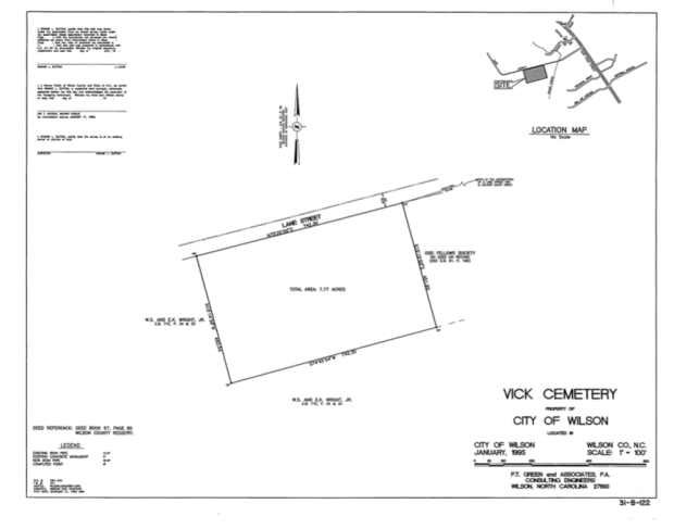
(6) A plat map of the cemetery and surrounding properties, including Odd Fellows cemetery.

Screen Shot 2020-02-22 at 9.29.38 PM.png

(7) Another plat map prepared by F.T. Green and Associates [now Green Engineering]. Under the label “Odd Fellows Cemetery” is this note: “No deed on record. See D.B. 81, p. 196.”

Screen Shot 2020-02-22 at 9.32.44 PM.png

(8) This map, also prepared by F.T. Green, reveals with terrible clarity the reality of the smooth field that is now Vick cemetery. This map shows the location of every grave found on the site. You have to imagine the boundaries: Lane Street the top, woods to the right (concealing Odd Fellows cemetery) and bottom. The clear strip bisecting the map likely indicates an access lane. Contrary to claims made by public officials in the 1990s, Vick cemetery was laid out quite regularly. Graves were oriented parallel to the road (roughly northeast to southwest) in rows running perpendicular.

Screen Shot 2020-02-22 at 9.32.04 PM.png

Please look more closely. The resolution is awful, but these — hundreds, thousands of? — little marks are not just marks. They are numbers. Each grave was numbered as it surveyed, and the city cannot locate its copy of the key to these numbers. Nor, apparently, can Green Engineering.

Screen Shot 2020-02-22 at 9.36.07 PM.png

The takeaway: the city (or its contractors) surveyed and assigned each grave a number; prepared a map of those graves; removed the gravestones; graded the site; stored, then destroyed the gravestones; and lost the key that identified any of the graves that could be identified. 

I need to sit with this for a minute to process my sadness and anger and profound disappointment in the city’s handling of the “restoration and improvement” of a public cemetery founded during the darkest days of segregation and neglected through and after its fifty years as an active burial ground. The graves of the thousands of African-Americans buried in Vick cemetery remain in situ, the names of their dead lost.

Vick Cemetery, Christmas Eve 2019. 

Emma Gay’s lands.

In 1918, John Griffin subdivided and sold a large parcel that had formerly belonged to Emma Gay. Griffin contemplated twenty lots with connecting rear alleys. This corner is easily recognized as the eastern gateway to Wilson’s black business block. Plank Road is modern Nash Street, and Stantonsburg Road is now Pender Street. Subsequent development, all commercial, suggests that most the lots were sold in multiples and consolidated.

The approximate location of Emma Gay’s lands.

Plat Book 1, Page 56, Register of Deeds Office, Wilson County Courthouse.

The estate of Albert Adams.

Albert Adams and Spicey Williams[on] registered their eight-year cohabitation with a Wilson County justice of the peace in 1866. Spicey Williamson Adams is almost certainly the Spicy listed in the 1859 inventory of Hardy H. Williamson’s enslaved property.

In the 1870 census of Spring Hill township, Wilson County: farmer Albert Adams, 50; wife Spicy, 37; and children Arch, 14, Arnold, 13, Frank, 7, Caroline, 5, and James, 2.

Albert Adams died near the end of 1878. W.T. Williamson was appointed administrator of his estate. Williamson estimated the value of Adams’ estate as about $400 and named his heirs as Frank Adams, Caroline Adams, Arnol Adams, James Adams, Guilford Adams, Albert Adams, an unnamed infant, and widow Spicy Adams.

For the support of Spicy Adams and their children, the court approved the transfer of property from Albert Adams’ estate, including a black mule; three head of cattle; 16 hogs; poultry; perishables like corn, fodder, bacon, potatoes and “turnups greens;” furniture; and cotton seed, totaling $378.25 in value. In January 1879, Williamson sold Adams’ cotton crop for $165.63 and paid off large debts to his bank and a mercantile firm.

Payment of debts owed to Branch, Hadly & Co., the bank that eventually became BB&T.


Payment of Adams’ account at the mercantile firm Moses Rountree & Co.

In the 1880 census of Spring Hill township, Wilson County: farmer Spicy Adams, 39, and children Frank, 19, Carline, 15,  James, 12, Calvin, 8, Albert, 6, and Dora, 1. Next door: farmer Arnol Adams, 24, and wife Sarah, 18.

On 15 September 1882, Ishmael Wilder filed for letters of administration for Spicy Adams. Wilder estimated her estimated her estate at $500 and named Arnold, Frank, Archibald, James, Calvin Busbee, Albert and Dora Adams as her heirs.

On 1 December 1883, a trio of appointed commissioners divided Albert Adams’ 173 acres among his and Spicy Adams’ heirs. Lot number one went to Arnold Adams; number two to Archibald Atkinson; number three to James Adams; number four to Calvin B. Adams; number five to Frank Adams; number six to Albert Adams Jr.; and number seven to Dora Adams.

[Ten years later, things fell apart. To be continued.]

Estate of Albert Adams, North Carolina Wills and Probate Records, 1665-1998 [database on-line], http://www.ancestry.com.