Maps

Black Creek Cemetery.

I spent a delightful half-hour on the phone the other night with Mrs. Dazell Batts Pearson! In a recent post, I queried “Does Black Creek Cemetery have an African-American section? Is there a separate cemetery?,” and the BWA-hive responded. Yes, said Sebrina Knight Lewis-Ward, and her grandmother not only knows where it is, but went to Minshew School and can locate that, too!

Mrs. Pearson, who is 90, recalled that the cemetery was active when she was a child and into the 1960s. Funeral processions travelled down a dirt path alongside the railroad, crossed a small wooden bridge across a ditch, and then went over an embankment to reach the cemetery. In recent decades, the cemetery, now even more difficult to reach, has become overgrown. Saint John Holiness Church owns the cemetery parcel, but it is not clear whether it actually established the cemetery.

I’m looking forward to meeting Mrs. Pearson during an upcoming visit to Wilson and touring Black Creek township with her and to researching more about Black Creek Cemetery. Stay tuned!

Plat Book 20, page 21, Wilson County Register of Deeds Office, Wilson.

Thank you, Sebrina and Mrs. Pearson!

Lane Street Project: response to the 18 August 2023 request re power poles.

Yesterday, I received responses to my July 23 and August 18 requests to the City of Wilson for public records concerning Vick Cemetery. Below is the response to the August 18 request, which concerned the power poles we recently deduced were placed in Vick Cemetery after the site had been cleared of headstones, graded, and adorned with a single monument.

As set forth in the letter below beginning at the third paragraph, the City has not located any documents related to the planning and installation of power poles in Vick and Rountree Cemeteries. Its sole responsive documents are references to data and maps found in the GPR report or at the City of Wilson’s GIS website. It provided screenshots of those images, which I have excerpted below. Bottom line: the poles were manufactured in 1997, which confirms they were installed no earlier than than year.


The red lines present power lines. The power poles are represented by blue dots. Date was provided for four steel poles, which are marked with blue rectangles. I have been way off with my estimates of their height. The first (closest to the substation) is 95 feet in height. The rest are 90 feet. If 90 to 95 feet is the height above ground (and not the length of the pole), the section of pole below ground is roughly 11 to 11.5 feet. In the middle of graves.

The poles were last inspected eight years ago and were found to be in good condition. What happens when they need to be replaced?

Lane Street Project: the City’s mystery cemetery project.

The Wilson Times‘ on-line edition reported today on the 611-page draft of the North Carolina state budget, which earmarks $66.3 million for Wilson County. Among the education, infrastructure, and recreation projects, there was this curious item:

What is this?

First, what is “Herring-Ellis cemetery”?

Here’s how I described it in a 11 September 2017 blogpost: “This small family cemetery is completely hidden in a copse of trees just outside the gates of Wiggins Mill Water Treatment Plant on Forest Hills Road in Wilson. Until relatively recently, this area — nearly four miles south of downtown — was outside city limits. Few gravestones are visible in the tangle of catbrier, pines and oak saplings, but several oblong indentations — some feet deep — mark burial sites just as clearly. This cemetery holds the remains of several generations of the family of Littleton and Judy Barnes Ellis, a couple born in slavery. The couple and at least four of their children — Bryant, Lucy, Maggie, Lizzie Sarah — are buried here on land that once belonged to Littleton Ellis.”

In November 2018, the Times reported about a group of Gentlemen’s Agreement students who spent time clearing Ellis cemetery in a service project with Wilson County Genealogical Society. North Carolina Representative Ken Fontenot, who was the students’ program mentor at the time, said they hoped “to find out more about those who are laid to rest in the area and the history behind them.” (When I read that, I reached out to reporter Olivia Neeley to let her know that information about the family buried in this cemetery was readily available at Black Wide-Awake. Since then, I’ve also posted information about Littleton Ellis’ enslavement.)

Where is the cemetery?

The cemetery lies inside a stand of trees just west of the intersection of Forest Hills Road and Forest Hills Loop, just before the driveway into the Wiggins Mills Water Treatment facility. It measures only .28 acres — 100 feet by 130 feet by 101 feet by 89 feet, or roughly two basketball courts.
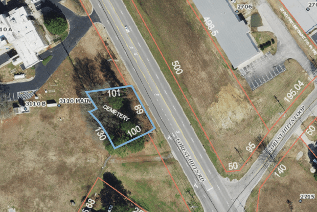
Aerial view of cemetery site courtesy of Wilson County NC GIS Website.

“$50,000 in capital improvements or equipment”?

A capital improvement is a permanent structural alteration or repair to a property that improves it substantially, increasing its overall value. What kind of improvements would cost $50,000 on a piece of land a quarter of an acre in size? What equipment?

And what in the world does the City of Wilson have to do with this?

This is most perplexing of all.

The City of Wilson does not own this cemetery. Tax records for the parcel list no owner. It is described simply as “Cemetery Forest Hills Rd.”

Why is the City willing to accept $50,000 from the State of North Carolina for capital improvements and equipment for land it does not own? What is the public interest in increasing the value of a private cemetery? (For obvious reasons, I’m especially interested in the City’s answer to this question.) The City has made clear that it is not in the business of maintaining private cemeteries, having turned a deaf ear to pleas for assistance with Odd Fellows Cemetery. (In fact, the summer after Lane Street Project began clean-ups at Odd Fellows, a contractor paid by the City for 25+ years discontinued mowing the front section of that cemetery. The City calls it a coincidence.) A year ago, the City deeded over Vick Cemetery to Wilson Cemetery Commission in an attempt to wash its hands of direct responsibility for that publicly owned site. (See Rodger Lentz’ email — and Grant Goings’ reply — here.)

Under what authority would the City make these improvements? Under what authority could they enter private property to do so? Who would administer the funds? And why do they need to buy equipment? If the plan is to clear Ellis of overgrowth, don’t the Cemetery Commission or Public Works Department already own sufficient equipment to handle this small job? If not, wouldn’t they contract out the work? (Begging the question, again, of why the City would reverse its position on its role in the restoration of private cemeteries and do anything at all at Ellis.)

Whose idea was this? The City of Wilson is hemming and hawing and poor-mouthing about restoration of a cemetery holding 4200+ graves, that it has owned for 110 years and has neglected and abused — but is lobbying for $50,000 to fix up a private cemetery with perhaps a dozen graves? And, apropos of poor-mouthing, why isn’t the City instead lobbying for state funds to do right by Vick Cemetery? And, if the City didn’t ask for this gift, why did whoever sponsored this bit of pork barrel choose to bestow his largesse on a quarter-acre private cemetery versus an eight-acre public cemetery?

Finally, in this year of 2023, is the City of Wilson getting ready to mess around in somebody else’s family’s graves? Have no lessons been learned about making decisions and taking actions in African-American cemeteries without permission and in contravention of state law???

Please make this make sense.

[By the way — Vick Cemetery is not on the published agenda for the September 21 council meeting, folks. Nonetheless, keep your foot on the City’s neck.]

Wilson’s 2043 comprehensive plan.

The homepage of the website for Wilson’s 2043 Comprehensive Plan declares: “The City of Wilson is a place for innovation, ideas, and creativity. Wilson’s strengths lie in its welcoming community, arts and culture, and nationally recognized programs and infrastructure. In the coming decades, Wilson will be poised to harness growth from the Triangle and take advantage of its place in the region to continue to build a welcoming place for all.”

More: “The Comprehensive Plan is a roadmap that provides guidance on where and how a community will grow and change over a period of time. The City of Wilson uses this as a policy document to set priorities and make important land use and investment decisions. The 2043 Update will revise sections of the Wilson Growing Together: The 2030 Comprehensive Plan to reflect the changes that have occurred in the community in the past decade and to support a renewed vision for the future of the community. In some cases, issue areas will be added that are not part of the original 2030 Plan. …

“The updated Comprehensive Plan will address land use, development, transportation, public investment, and identify other community priorities. The Project Team, led by City of Wilson staff, was supported by local consultants at Clarion Associates and VHB. As part of this process, the City of Wilson gathered input from the community to guide the development of a renewed vision for Wilson.”

The image below is a detail from the Comprehensive Plan’s Future Land Use Map. The parcels shaded blue have been designated “institutional” for future land use zoning. “Institutional” land has “uses related to community services, such as fire stations, libraries, schools, civic buildings, water treatment plants, and the like.”

I placed the upper circle over Maplewood Cemetery, which is appropriately shaded blue. What is going on in the oval though?

Here’s a close-up of Bishop LN. Forbes Street. The blue blocks on the left represent various churches colored “institutional.” The blue block at the top is B.O. Barnes Elementary School. The smaller blue blocks below it are Rountree Missionary Baptist Church and the two halves of its cemetery on B.L.N.F. Street. Strangely, though, the other five cemeteries on the street are shaded maize, “2-4 units/acre (med-density residential),” and part of Odd Fellows is green, “agricultural residential (rural residential).” Huh?

Why would these cemeteries be marked for the same future use as the neighborhoods around them? An oversight? Nefarious design?

The City is holding two more Open Houses for the public to review and provide feedback on the draft Comprehensive Plan. Ask why Vick Cemetery and Odd Fellows Cemeteries and the other L.B.N.F. cemeteries are not “institutional.”

Thanks to Jon Wesley Mullins for bringing this to my attention!

[Update: 9/18/2023 — the map has been updated, and the Masonic, Hamilton, and Rest Haven Cemeteries are now blue! Vick remains in limbo, but we appreciate this start.]

Lane Street Project: a 1995 aerial view of Vick Cemetery (or: aerial imagery shall set you free, Wilson).

And another one, this time from 1995. Lane Street (now Bishop L.N. Forbes Street) has been paved. What else can we see, besides “the devil is a lie”?

The upper left quadrant:

The wooden poles are clearly visible on the north side of the street and have been joined by a single wooden pole on the south side. That pole is still there, anchored by one guy wire. No sign of the steel poles yet. At (1) and encircled throughout are the headstones still standing after Vick was cleared of overgrowth in 1995. At (2), Lane Street is paved here. The dark line running parallel to the edge of the blacktop is the shadow of the higher southern edge of the ditch bank. Near the right side of the image, the shadow widens. This is high point of this edge of the cemetery. At (3), what appear to be tread marks from the heavy equipment used to clear the site. At (4), the sole exposed vault cover remaining in Vick today. (Actually, the sole grave marker of any kind.)

The upper right quadrant:

The cut in the ditch bank is a reliable landmark in Vick Cemetery. At (1), the access point for the “clean-up” of the cemetery. It’s now the entrance and parking lot. And look at Odd Fellows Cemetery! The trees up front, the clearing in the middle — both surprises to those who know its current state. At (2), the old Odd Fellows driveway. At (3), the short ditch between Odd Fellows and Rountree Cemeteries. At (4) and (5), two drainage ditches that once creased the east side of the cemetery. Though both were filled in when the site was graded, (4) is still detectable as a dark green stripe across the cemetery’s surface. At (6), several headstones are visible. At (7), this may be the pile of dumped concrete and other trash that we found in Odd Fellows near the fence between the cemeteries. At (8), headstones visible in Odd Fellows. The one directly below the 8 may be Henry Tart‘s obelisk.

The lower right quadrant:

At (4) and (5), the tail ends of the ditches identified above. 4 was deep enough to impact the placement of graves, as seen in the detail from ground-penetrating radar below. New South (incorrectly, I believe) concluded the ditch, partially detected and highlighted in yellow, was a buried path. I’ve extended its course with a dotted yellow line. At (6), note that there’s still no cut-through for the natural gas pipeline.

The lower left quadrant:

Graves and headstones clearly visible. Compare the area within the square to this detail from the GPR report:

Many thanks to Olivia Neeley for sharing this photograph, which was obtained via a public records request made to Wilson County GIS. (Kudos to an agency that understands its obligations under the law!)

Lane Street Project: “linear anomalies.”

The power poles are not the only utilities in Vick Cemetery.

New South Associates’ GPR report revealed three “linear anomalies” that they interpreted as utility lines. Two of them appear to postdate the 1994 grading of the cemetery and disturbed multiple graves during construction. What in the world are they?

Utility Lines 1 and 2 are marked below. (New South believes Line 3, the pink T-shape off the green path, dates to the period the cemetery was active. It does not cross graves.)

Per Wilson County GIS information, “soil and water drainage tiles” run under the southwest quadrant of Vick Cemetery. It is not clear if this is what GPR detected. It would seem an odd location for drainage infrastructure as this is a relatively high, flat section of the site. If they are drainage lines, who placed them and when? I’ll seek more information from Wilson County Soil and Water Conservation District.

Lane Street Project: where the last gravestones stood.

This, of course, is the map of Vick Cemetery plotting the locations of all its visible graves circa 1995. The version I received from the City in response to a records request was grainy, but Wilson Times supplied a cleaner version. The City has not provided (or cannot provide, because it is lost or was never created in the first place) a key to the numbers or otherwise identifying the locations and names on gravestones. However, a friend with surveying experience has cracked the code on the numbering system.

To recap, a surveyor prepared this map ahead of the removal of overgrowth and grading of Vick Cemetery. All detectable graves, whether marked by gravestones or indicated by grave depressions, were numbered and plotted on the map.

Per information, the cemetery’s corner pins and other control points are labeled with the lowest numbers and are highlighted in yellow on the map above. On the right, a broad white expanse reveals that the surveyor did not detect any graves in a strip of land along its northeastern edge, representing approximately twenty percent of the cemetery’s surface. (This is the edge that includes today’s parking lot.) It’s not clear why this is so, as gravestones and slumps are clearly visible today on the other side of the fence that divides Vick and Odd Fellows, and GPR has revealed that this section of the cemetery is quite dense with grave anomalies.

The numbers 20 to about 200 were assigned to graves marked with objects, whether headstones, foot stones, vault covers, slabs, or other markers. Those graves are highlighted in light blue. I know it’s a little tough to see, so I’ve zoomed in one section:

I apparently will never lose the ability to be struck dumb by a Vick discovery. Will you look at this? Look at that row of five graves numbered 109, 110, 111, 112, and 113. Surely this was a family plot, marked with headstones, until the City pulled them up and tossed them, figuratively speaking, in a pit.

Per this map, just under 200 grave markers were standing in 1995 when the City hauled them out. Untold numbers of markers, like the dozens we’ve unearthed in Odd Fellows Cemetery, undoubtedly lay just below the soil surface. We may not know the names of these 200 but, with this highlighted map and the precise location data supplied in New South Associates’s report, we know exactly where they were.

The location of graves 109 through 113 on the Vick Cemetery GPR map.

Lane Street Project: an earlier look at Lane Street.

My ears pricked up when I spotted this volume at Wilson County Register of Deeds office, but it wasn’t as helpful as I thought. It holds “plans and profiles” of proposed state highway projects in the county. Bishop L.N. Forbes Street, formerly known as Lane Street and State Road 1564, only appears once, and then only at its junction with  Martin Luther King Jr. Parkway, also known as Highways 264 and 58. I’d hoped to find documents related to the street’s paving some time in the late 1980s, but as paving didn’t happen until the street was annexed into city limits, it likely was not a state-funded project. 

Still, perusing the volume was not a complete waste of time. Page 1-D of Project 6.3410029 is one of the plat maps prepared in 1968 for a project to widen and improve 264/58 from U.S. 301 (then the city limit) to the split where NC 58 veers south toward Stantonsburg. In the map detail below, the old Rountree Missionary Baptist Church (a clapboard building I vaguely remember from childhood) is bottom left. Running alongside the church lot to the right is the eastern end of Lane Street. It’s a little difficult to see, but in heavy script spanning the street is “30′” over a double-ended arrow, then “Exist. R/W,” in other words, an existing thirty-foot right-of-way. 

A slightly closer look reveals the street width (highlighted in red) within the boundaries of the 30-foot right-of-way. (The little blob by the road, followed by, “GUM”? That’s a sweetgum tree standing inside the right-of-way.) Recall that today’s right-of-way is 60 feet wide. 

It’s difficult to know how close to scale this map is, but Lane Street/S.R. 1546 appears to be about half the width of the right-of-way, or about 15 feet wide. (For perspective, a single-car residential driveway is 10-12 feet wide.) Lane Street was unpaved in 1968 (and 20 or so years thereafter), but was a maintained road, meaning it was regularly scraped and resurfaced with fresh dirt or gravel. However, in the first several decades of Rountree, Odd Fellows, and Vick Cemeteries, this would have not have been much more than a dirt track, heavily rutted from wagon wheels and impossibly muddy after hard rains. 

1968, of course, was well after the period of active burials in the Lane Street cemeteries. A view of the older road is useful, however, to envision where graves may now lie in relation to the modern road and right-of-way.

Lane Street Project: the numbers.

The first clue to the density of graves in Vick Cemetery came in response to my September 2019 request for public records related to the Lane Street cemeteries. A map, prepared by F.T. Green and Associates [now Green Engineering], showed the location of every grave observed by contractors clearing the cemetery in 1995. The resolution of the copy the City sent me is awful, but close inspection revealed that what seemed to be little marks were actually numbers. Each grave was numbered as it surveyed, but the city cannot locate its copy of the key to these numbers.

I recently had the chance to examine a cleaner print of this document, and it broke my heart all over again. The image below is a close-up of just a section of the map. I had counted 1491 of the little marks; I was off by about 35. But the contractor was off by more than 2700. We now know there are 4,224+ graves in Vick. 


Lane Street Project: absent a plat map, a photographic analysis of the survey flags.

Today, New South Associates is scheduled to return to Vick Cemetery to do whatever it is the City has asked it to do. Per news accounts, “New South will flag unmarked graves along the cemetery’s property edges and provide a map showing which graves were marked, officials said.” Does this mean New South will perform GPR surveying in the areas along the edges of the cemetery not surveyed last year?  The City has not meaningfully engaged the descendant community since the Mayor promised transparency at the May 11 public forum, so we have no idea.

In the inexplicable absence of a plat map of the property, here are a few observations based on photos of the survey flags. First, an aerial (courtesy of Bing.com) showing the four power poles along the front edge of the cemetery. (I have previously referred to the three enormous steel poles, but there is a fourth wooden pole, labeled 1 below.)

These photographs were taken yesterday. In the first, the viewer is standing close to and with his back to the ditch at the far western edge of the cemetery. Wright Farm is at right; Vick Cemetery at left. Two survey flags mark the corner at the boundary of the farm and cemetery. The wooden power pole, which bears a City of Wilson tag, appears to be imbedded in the property line. The pole is tethered to a guy wire anchored in the ground. The anchor rod is inside the cemetery property line. Power poles are typically set in the ground at a depth of 10% of the overall height of the pole, plus two feet. Thus if this is a 30-foot pole, five feet of the pole is below grade, and 25 feet above. The anchor rod is attached to an anchor also set several feet below ground. To the right of the power pole is a fiberglass post marking a natural gas pipeline. This pipeline likely was laid circa 1959, when the first gas pipelines arrived in Wilson, but there is no record of a utility easement for it. We know it wraps around two sides of the cemetery.


The next photo was taken from a vantage point in the road several feet east of poles 1 and 2. Four guy wires anchor pole 2; a conifer has grown up around their anchor rods. All are well inside the boundaries of the cemetery. Note the survey flag placed several feet back from the edge of the ditch. As I’ve noted before, the “official” property line here is determined by the 60-foot public right-of-way, which is measured 30 feet in either direction from the center line of the street. No such right-of-way would have been observed during Vick Cemetery’s active period from 1913 to about 1960, and it is likely that graves extend into this space.

Consider Rest Haven and Masonic Cemeteries, which were laid out around the corner on the same street circa 1900, on land that was then outside city limits. After the City annexed the area, it needed to widen and pave Lane [now Bishop L.N. Forbes] Street. In order to achieve standard street width, curbing was laid to the very edge of the graves, resulting in dozens (if not hundreds) of graves inside the public right-of-way. See, for example:

The next photo shows a line of three survey flags marking the front edge of the property at the public right-of-way. It’s difficult to say — a survey map would be definitive — but it appears the power pole is inside the cemetery property. The steel poles are enormous. If they are, say, 60 feet tall, then eight feet of that length is underground. New South did not survey this area in its first visit to Vick.

And finally, a close-up of the bottom of pole 4, taken from the driveway into the small parking lot at Vick Cemetery, which has room for about five cars. At bottom left, we see the corner of the parking area. New South surveyed only the bumped-out area of the parking stalls and found evidence of 18 graves beneath it. The power pole is ten to fifteen feet away. In just a sliver of the little peninsula of grass between the parking lot, the pole, and the ditch, the survey found ten graves.

Many thanks to B.W. and T.S. for quick photos. Lane Street Project is a community collective. It’s going to take all of us to stay on top of what is happening at Vick Cemetery. This is a Sankofa moment if ever there were one. We don’t have to look back very far to see what needs to happen differently going forward.

Vick Cemetery’s descendant community and its allies demand transparency, accountability, and dialogue. Join us for an initial  Zoom meeting tonight to learn more.